


Diolkos Road Design Software
Integrated and autonomous road construction software
Diolkos is a complete and autonomous street design software. It covers all cases of road construction such as highways, provincial and urban roads, forest roads, etc. It also deals with complex road projects such as junctions, parallel service road network etc.

The road planning software is an unrivaled and comprehensive solution for the study of all cases of road projects, in a state-of-the-art and high-speed 3D graphical environment.
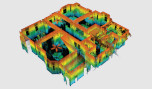
It is a stand-alone software for creating, editing and viewing a 3D terrain model. Instant creation of TIN (100000 points in 3 sec) and iso-elevations. Define breaklines and holes in the model. Point, breakline and triangle filters. Import/export data from/to XYZ, DXF files.
It has O.M.O.E. Regulations. and RAS. Study of horizontal planing, mecotomy, diagrams, cross-sections, earthworks, pre-measurements. Automatic check of compliance with O.M.O.E. Study of gradients, expansions, V85 velocities, drainage layer diagrams.
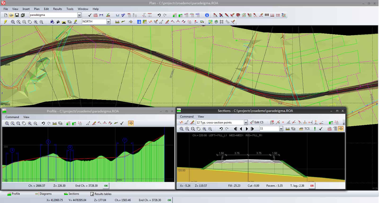
Easy and quick input and modification of project geometry. On-line perspective visualization of road projects (simple and complex), virtual movement along the route. Check final visibility along the road. Supervised graphical definition of standard cross-sections of random shape. Free material matching. Library of standard sections.
Fast calculation of cross-sections at each modification of the drawing and automatic calculation of the final 3d terrain-road model. Automatic re-insertion of all study stakes after each layout change. Study of parallel projects. Free processing of parallel projects without restrictions from the direction of each engraving and the projections of the piles. Optimization of ground movement, study of rear tracks of each type of vehicle.
Hydraulic study of open flow projects of random cross-section. Study of flow in an existing bed, scaling of benefits, calculation of bed zone. Automatic production of plans according to the requirements of hydraulic studies.
Project measurements (Import/export of XYZ, GRD files). Free entry or modification of the lines of a section (graphically or with the keyboard). Tools for automatically creating layers from measurement data. On line design in CAD with ActiveX Automation technology or DXF file production.
Simple task management. All the study of a project is saved in a file. Free ongoing and immediate support from road and plumbing engineers. Easy to learn. Greek Menus and Manuals. Continuous development and updating by engineering developers.
Terrain relief from triangles (TIN) or 3d lines (e.g. contours). Random geometry of ditch and embankment slopes. Study of upgrading an existing road. Calculation of drainage layer, S.E.O./I.B.O., anchoring steps, soil remediation, retaining walls, safety parapets.
Flexibility & Capabilities
Design
Study of horizontal alignment, vertical alignment, superelevations, widennings, V85 and drainage layer.
3D
Real time 3D presentation of the project. Movement along the road in real time.
Construction
As built drawings by using data collected in the worksite. Machine control data preparation.
Easy
Easy introduction and modification of the project geometry. Quick calculation of all sections in each modification of the horizontal alignment.
Cross Sections
Graphic definition of the standard cross-section and assignment of materials. Extensive library of standard cross-sections.
Support
Support services from civil engineers with great experience in road and hydraulic projects.
