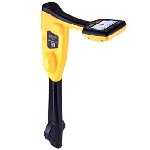
vLoc3 RTK-Pro
Utility Locator with Survey-Grade GNSS
The vLoc3 RTK-Pro receiver, by Vivax-Metrotech, is the first to add RTK GNSS accuracy to a utility locator. Using the RTK-Pro internal cellular module with 4G LTE capabilities, the operator has the ability to connect to NTRIP RTK (Real-Time Kinematic ) caster that provides RTCM 3 corrections. By utilizing these corrections, the operator can collect both utility location data along with the geographical location of the utility with survey-grade accuracy.
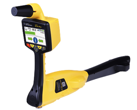
The RTK-Pro was designed for use at all operator levels, utilizing user-friendly and intuitive locate screens. Operators simply confirm the utility data with the press of a button and align the electronic spirit level to store the data. All field data is sent to the cloud and retained in the receivers onboard storage for review and exporting to external mapping programs.
The highly user-configurable vLoc3 series contains eight passive locate modes, fault find mode, SD (showing the direction of outgoing current), and a range of configurable frequenciesn from 98Hz to 200 kHz. Visual and mechanical vibration alerts can also be configured by the user providing warnings for shallow depth, overload, overhead cables, and excessive swinging. Optional features include Tx-Link that enables the user to change the frequencies of the transmitter, power output and operate most of the features of the transmitter remotely.
Signal Distortion Indicators
Signal distortion is an intrinsic problem and is the result of additional currents flowing in the ground other than the outgoing signal from the transmitter. The vLoc3 RTK-pro gives ‘on the fly,’ color-coded indication of distortion on the LCD’s signal strength bar graph. The bar graph will change colors depending on the level of distortion.
- A green bar graph indicates clean locating conditions with very low distortion.
- A blue bar graph indicates a medium level of distortion.
- A red bar graph indicates very high distortion. Both Peak and Null locates are subject to significant positional errors.
Programmable Alerts and Warnings
Real-time visual and mechanical vibration alerts can be set to provide warnings for shallow depth, overload, overhead cables, or excessive swinging.
- Swing Alert
This indicates that the operator is swinging the Locator excessively and could result in misleading information. - Signal Overload
This is usually caused by operating very close to a power transformer or placing the unit very close to a transmitter in the Induction mode. - Overhead Cable
This indicates that the signal is mainly radiating from above. This is usually caused by the signal traveling along with overhead cables. - Shallow Cable
This indicates that the locator has detected a cable that is possibly less than 5.9”/15 cm deep. Proceed with caution.
| Technical Characteristics | |
|---|---|
| GNSS Satellite Tracking | GPS, GLONASS, Galileo, BeiDou |
| Cellular Connection | Nano SIM tray 4G LTE connection Direct data storage to the cloud |
| Log data with press and tilt | 2 DRMS horizontal accuracy displayed in real time |
Classic Screen
Bar graph indicator with the addition of three color-coded distortion levels. Peak, Null, Simultaneous Peak with Arrows, Omni Peak locating modes.
All relevant utility data
Is directly sent to the cloud along with RTK position of the utility.
Vector Screen
For use when access directly over the utility is not possible. Using two sets of omni-directional antennas, the utility offset and depth are displayed.
Multimedia
Below you will find all available multimedia, including videos & images.
Related Products
See related products from this manufacturer


Get a Quote
You can fill out the contact form below and one of our representatives will contact you shortly.