UtilityScan Pro
Industry Standard in GPR for Utility Mapping and Locating
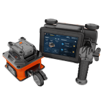
With UtilityScan Pro, by GSSI, users can quickly identify and mark the position and depth of metallic and non-metallic objects; including utilities such as gas, communications and sewer lines as well as underground storage tanks and PVC pipes. Based on the SIR 4000 controller, the UtilityScan Pro provides the GPR professional with solutions to any underground locating situation.
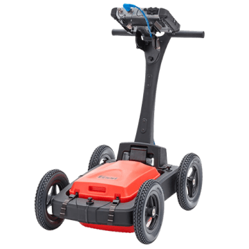
The UtilityScan® Pro is GSSI’s premium utility locating system, offering users modularity within one scanning system. The UtilityScan Pro system provides a non-destructive means to accurately locate metallic and non-metallic underground utilities.
UtilityScan Pro is ideal for locating the position and depth of metallic and non-metallic objects, including service utilities such as gas, communications, sewer lines as well as underground storage tanks and PVC pipe. It is also used to help identify shallow geophysical characteristics and to conduct site assessments. The UtilityScan Pro is based on the advanced SIR® 4000 controller, and can be used for
additional applications, including bridge and concrete inspection, by interchanging the cart and antenna configurations.
The UtilityScan Pro is typically used for:
- Underground utility detection
- Environmental remediation
- Damage prevention
- Geological investigation
- Archaeology
- Forensics
- Road inspection
| Technical Characteristics | |
|---|---|
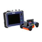
| System | SIR 4000 |
| Antennas | Compatible with all GSSI antennas |
| Number of Channels | Records data from 1 single-frequency antenna or 1 dual-frequency antenna |
| Data Storage | 32 GB Flash, 1 GB RAM |
| Storage Capacity | 32 GB |
| Display | Enhanced 10.4″ LED display with internal high brightness, Active matrix 1024 x 768 resolution and 32-bit color |
| GPS | Data logged internally |
| Display Modes | Linescan, Linescan plus O-scope, Wiggle trace, Full 3D, 256 color bins represent amplitude and polarity of the signal |
| Max Depth | 0-12 m (0-40 ft) |
| Environmental Rating | IP65 |
| Antenna Options | 400 MHz, 300/800 DF, 350 HS |
| Weight | 27.2-34 kg (60-75 lbs) (cart dependent) |
| Optional Software | RADAN 7 for UtilityScan, RADAN 7 |
| Accessories | LineTrac, Juniper Geode GPS, Tripod for 3-wheel survey cart |
System includes
- SIR 4000 Control Unit
- 400 MHz, 300/800 DF, or 350 HS Antenna
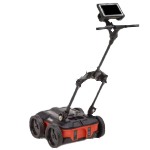
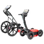
- Choice of 3-wheel or 4-wheel cart
- 2 m control cable
- SIR 4000 sunshade
- SIR 4000 AC/DC power supply
- Lithium-ion battery (2)
- Dual-bay battery charger
- Transit case
- 2-year warranty
Features
Below, you will find the main features of the product.
Data Visualization
The UtilityScan Pro system features our state-of-the-art SIR 4000 controller and can incorporate an optional AC power accessory. The SIR 4000 controller incorporates advanced display modes and filtering capabilities for in-the-field processing and imaging. The LineTrac accessory for digital antennas adds the ability to detect AC power and induced RF energy present in buried utilities.
Fully Customizable System
Users can customize the UtilityScan Pro with multiple antenna offerings and cart options. The tailored options provide survey flexibility, from smooth prepared surfaces to rugged terrain with our rugged four-wheel cart, and suit a number of utility locating applications.
Mark with Confidence
The UtilityScan Pro delivers exceptional data quality and is rugged enough to withstand the job site’s toughest conditions. Locate subsurface utilities with confidence.
Multimedia
Below you will find all available multimedia, including videos & images.
Related Products
See related products from this manufacturer
Get a Quote
You can fill out the contact form below and one of our representatives will contact you shortly.